
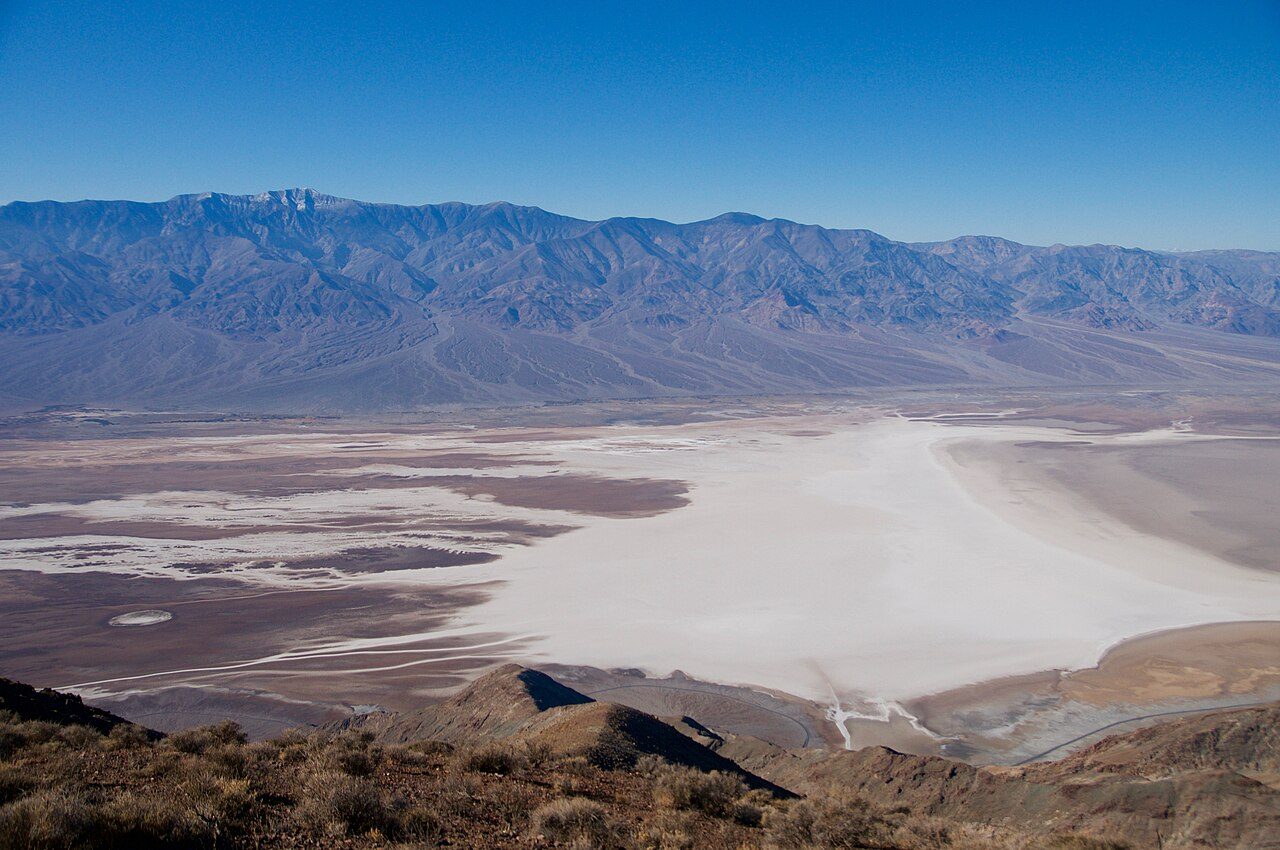

Death Valley is a long, narrow basin in eastern California, just over the Nevada line, squeezed between the Panamint Range on the west and the Amargosa Range on the east. Its floor drops to 282 feet (86 m) below sea level at Badwater Basin, the lowest point in North America, while Telescope Peak on the western rim rises above 11,000 feet. That difference in height, along with the dry air and the walls that trap heat, makes it one of the hottest places on Earth.
The number most people know is 134 °F (57 °C). The National Park Service records it as the hottest air temperature ever measured in Death Valley, taken at Furnace Creek, then called Greenland Ranch, on July 10, 1913, and the World Meteorological Organization lists it as the world record. That reading has long been questioned. Weather historians have argued that the 1913 observer's numbers do not fit the surrounding stations and that the true high that day was probably several degrees lower; a 2025 paper in the Bulletin of the American Meteorological Society made the case again. As of late 2026 the record still stands officially. What no one disputes is that summer readings of 120 °F (49 °C) in the shade are routine.
People lived here long before the park. The valley is the homeland of the Timbisha Shoshone, who still have a community at Furnace Creek. In the late 1800s, borax mining brought the mule-team wagons that became the valley's emblem, and mining camps boomed and faded across the surrounding hills. President Herbert Hoover proclaimed Death Valley National Monument in 1933. The California Desert Protection Act of 1994 enlarged it and made it a national park, now the largest in the lower 48 states at more than 3 million acres.
For a day trip from Las Vegas, the classic route enters from the Nevada side and works around Furnace Creek. Within a short drive are Zabriskie Point's folded badlands, the salt polygons of Badwater, the colored hills along Artists Drive and, farther north, the Mesquite Flat Sand Dunes near Stovepipe Wells. It is a long day; distances inside the park are large, and the drive alone takes several hours each way.
Highlights
Badwater Basin
A vast salt flat at the lowest point in North America; a sign on the cliff above the parking area marks where sea level would be.
Zabriskie Point
A short walk up to a viewpoint over yellow and brown badlands carved from old lakebed deposits, at its best at sunrise.
Dante's View
A mountaintop overlook high on the Black Mountains, looking straight down onto Badwater and across to the Panamint Range; often much cooler than the valley floor.
Mesquite Flat Sand Dunes
Rolling dunes near Stovepipe Wells, easy to walk onto from the road; softest light early and late in the day.
Heat
The NPS warns summer visitors not to hike at low elevations after 10 a.m.; temperatures inside canyons can run far above the official air temperature because the rock radiates heat. Visitors have died of heat in the park in recent summers. Stay near your car and air conditioning, carry plenty of water, and if your car breaks down, stay with it.
Climate compared with the Strip
Normal daily high and low by month at NOAA's Death Valley NP (Furnace Creek) station (-194 ft), with the Las Vegas high as a dashed line. In July this station averages 117°F, +13°F against the Strip; in January 67°F (+9°F).
Normal high Normal low Las Vegas high Precipitation
| Month | Jan | Feb | Mar | Apr | May | Jun | Jul | Aug | Sep | Oct | Nov | Dec |
|---|---|---|---|---|---|---|---|---|---|---|---|---|
| High °F | 67 | 74 | 83 | 91 | 101 | 111 | 117 | 116 | 108 | 93 | 77 | 66 |
| Low °F | 43 | 49 | 57 | 65 | 75 | 84 | 91 | 89 | 79 | 64 | 51 | 41 |
| Rain in | 0.37 | 0.52 | 0.25 | 0.10 | 0.03 | 0.05 | 0.10 | 0.10 | 0.20 | 0.12 | 0.10 | 0.26 |
| Days ≥100°F | 0 | 0 | 0 | 5 | 18 | 28 | 31 | 31 | 26 | 8 | 0 | 0 |
Sunset here
Sunset and the end of civil twilight at Furnace Creek Visitor Center on the 15th of each month (local time, daylight saving included), and the difference from the Strip. Mountains to the west can hide the sun earlier than the computed time.
| Date | Sunset | Dark | vs Strip |
|---|---|---|---|
| Jan 15, 2027 | 4:56 pm | 5:24 pm | +6 min |
| Feb 15, 2027 | 5:28 pm | 5:55 pm | +6 min |
| Mar 15, 2027 | 6:55 pm | 7:21 pm | +7 min |
| Apr 15, 2027 | 7:22 pm | 7:48 pm | +8 min |
| May 15, 2027 | 7:47 pm | 8:16 pm | +7 min |
| Jun 15, 2027 | 8:07 pm | 8:38 pm | +8 min |
| Jul 15, 2027 | 8:06 pm | 8:35 pm | +8 min |
| Aug 15, 2027 | 7:38 pm | 8:06 pm | +7 min |
| Sep 15, 2027 | 6:55 pm | 7:21 pm | +7 min |
| Oct 15, 2027 | 6:11 pm | 6:37 pm | +6 min |
| Nov 15, 2026 | 4:39 pm | 5:06 pm | +6 min |
| Dec 15, 2026 | 4:33 pm | 5:02 pm | +5 min |
Sources
- nps.gov/deva/learn/nature/weather-and-climate.htm
- nps.gov/deva/planyourvisit/fees.htm
- nps.gov/deva/learn/historyculture/index.htm
- nps.gov/deva/learn/news/medical-2024-07-19.htm
- nps.gov/deva/learn/news/fatality-7-19-2023.htm
- nps.gov/jotr/learn/management/caldesprotect.htm
- nationalparkstraveler.org/2008/10/thanks-california-desert-protection-act-death-
- theweathernetwork.com/en/news/weather/severe/56-7-c-study-questions-validity-of-
- accuweather.com/en/weather-news/death-valley-top-5-again-130-degree-reading-disp
- headlines.ametsoc.org/2025/11/14/global-record-in-question-could-death-valley-lo (403 to our bot; known from search snippet only)
- nbcnews.com/news/us-news/death-valley-recognized-posting-worlds-hottest-temperat
- en.wikipedia.org/wiki/Death_Valley_National_Park
- wikidata.org/wiki/Q36022301 (visitor center coordinates; matches OpenStreetMap)
Uncertain or disputed
- 134 °F record: NPS states it plainly (July 10, 1913, Furnace Creek). The dispute (Christopher Burt and William Reid; 2025 BAMS paper 'Death Valley Illusion') is from press reports and the AMS headline page, which blocked our bot. No WMO review or decision found as of 2026-10-29; text says 'still stands officially'.
- 'Greenland Ranch' as the 1913 station name: press and Wikipedia; NPS page says only Furnace Creek.
- Telescope Peak 'above 11,000 feet', Panamint/Amargosa/Black Mountains geography, Artists Drive: Wikipedia and general NPS maps; not checked on a specific nps.gov page.
- Timbisha Shoshone community at Furnace Creek and borax/mule-team history: NPS history page mentions the Timbisha and a mule train photo but not the details; details from Wikipedia.
- 'More than 3 million acres' and 'largest in the lower 48': National Parks Traveler, Frommers and the 1994 Act; not on the NPS history page.
- 'Several hours each way' and the Nevada-side entry route: general; no official driving time cited.
- Sea-level sign at Badwater and Dante's View being cooler: common knowledge, not verified on nps.gov.
- 'If your car breaks down, stay with it': standard NPS desert advice, not confirmed on a current nps.gov page (the main hot-weather-safety page returned 404).